|
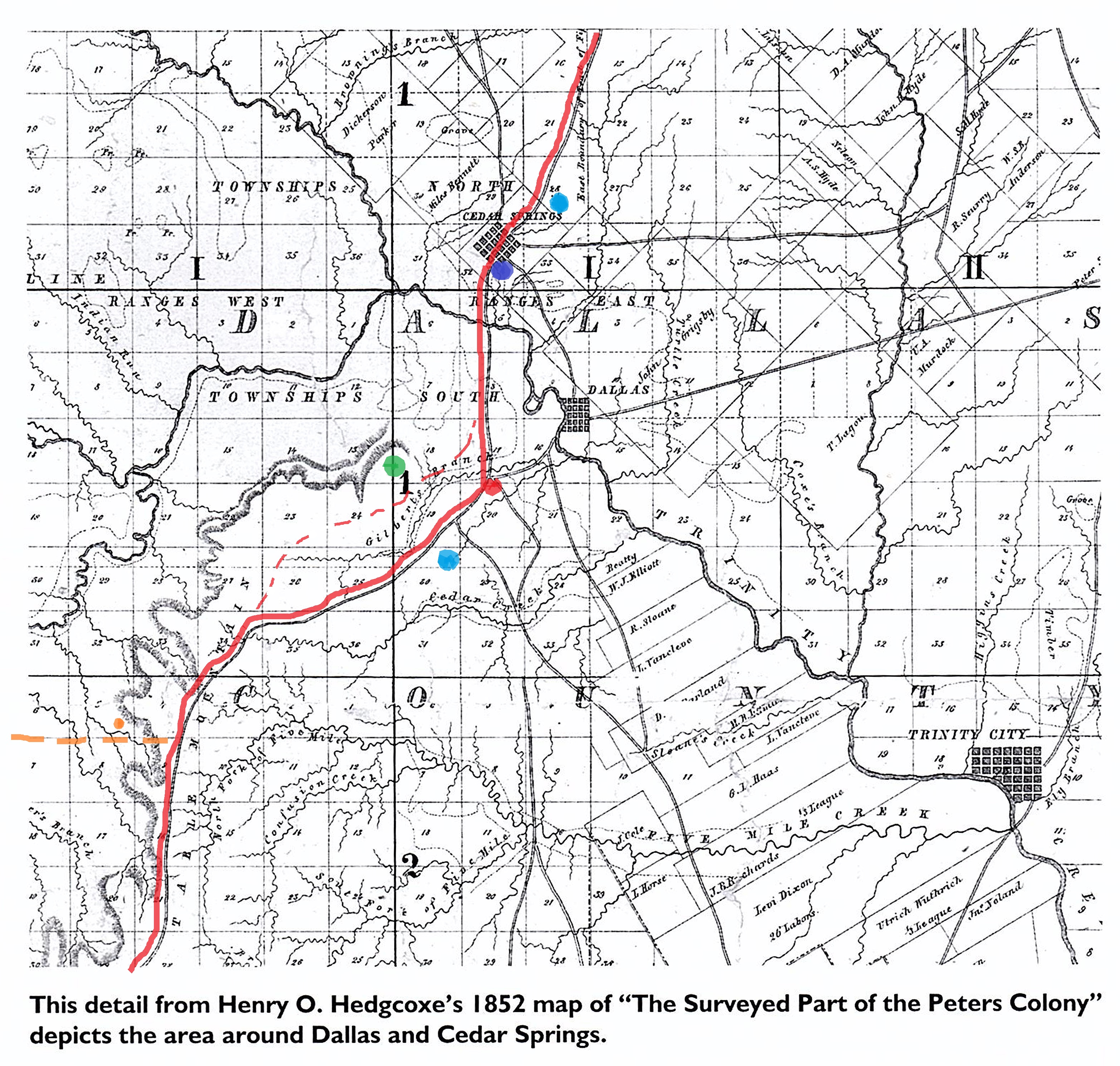
Fragment from an 1852 map
from Legacies Journal; Spring 2016; page 5
(click on map for larger view)
|
The most prevalent prehistoric north-south trail through what-is-now Dallas County
followed the ridge lines across the open prairies between Mountain Creek and the Trinity River (from the south)
and the Elm Fork and Turtle Creek / White Rock Creek (to the north).
This Ridge Route became the 1841 Republic of Texas Military Highway, from Austin to the Red River
(also called the Preston Road). That ancient natural highway is outlined in red on this detail from a
Peters Colony map of 1852. Rather than being an exact wagon-rut, the prehistoric Ridge Route was a broad
and only loosely defined trail way.
The purer Ridge Route passed near two prehistoric Indian mounds (green dot) along the
dotted-red-line segment, but a short cut went south of Coombes Creek (originally called Gilberts Creek),
probably because it passed the abundant fresh water of Kidd Springs (lower blue dot). Crossing the Trinity's
flood-plain near modern Sylvan Avenue, the Military Road had fresh water at
Cedar Springs (northern blue dot). A nearby frontier blockhouse fort was planned (purple dot) though
it is now uncertain whether it was ever actually built. Alexander Cockrells White House homestead cabin (orange dot) was
near where the trail headed west (dashed orange line), following approximately the modern Pioneer Parkway
(Highway 303) west to what-is-now Fort Worth. The site where the Ridge Route
reached the brow of the escarpment, just before going down into the Trinity River flood-plain,
is marked with a red dot and is now the site of the Rock Lodge.
|
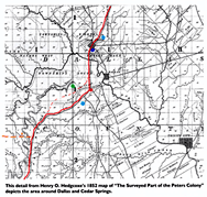
an 1860 map
(click on map for larger view)
|
The Ridge Route appears also this 1860 map of Dallas County, and would have possibly
been used as one of the routes of early cattle drives (the so-called the Shawnee Trail).
It is easy to imagine that local wheat farmers hated the ever larger herds of cattle wandering
across their farms, and as the Lancaster Road offered a slightly shorter way to Austin,
the old Ridge Route fell out of use and was fenced away completely when
barbed wire started enclosing the open prairies in the 1880s.
In 2009 I wrote a longer essay about the Ridge Route. (Click here).
|