|

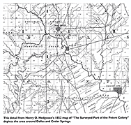
Fragment from an 1852 map
from Legacies Journal; Spring 2016; page 5
(click on map for larger view)
|
Thinking about what the first White Settlers saw, I concluded that
the Coombes Creek must have been relatively shallow, its streambed filled with trees;
while everywhere else, including (surprisingly) the slopes of the escarpment,
was covered by thick prairie grasses upon which giant migratory herds of bison came to graze.
In 2009 I wrote an essay imagining the prehistoric landscape.
(click here)
In 2016, the Legacies Journal published an article featuring this fragment of an 1852 map
drawn by the Peters Colony -- the first surveyed map of this region.
I was delighted to realize that not only does it show the preliminary land-grant survey boundaries
and the early roads of the district, but it also has a series of dotted lines describing the edges
of forests.
|

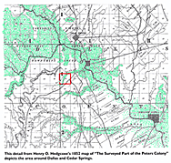
Same 1852 map: Colored
(click on map for larger view)
|
Adding a red outline around the square mile of the William Myers Section
and coloring the mapís forested areas in green, this map then is a bit easier to read.
Much is inaccurate or incomplete on this first attempt to map the details of the region.
On the William Myers Section the Coombes Creek (here labeled "Gilberts Branch") is shown partially in the wrong location.
The drafters must have had many problems interpreting their surveyors' field notes.
Nevertheless, the overall reading is quite clear: the major drainageways were filled
with trees while everywhere else was open grassland prairie, including the slopes of the escarpments.
Coombes Creek must have been relatively shallow, a tangle of tall tree growth
cluttered by dead logs and occassional beaver ponds.
I take the grass-covered hillsides of the escarpments as evidence that Native Peoples had been periodically
burning the prairies, in order to grow fresh grasses to attract migrating herds of bison (but records are scant).
|